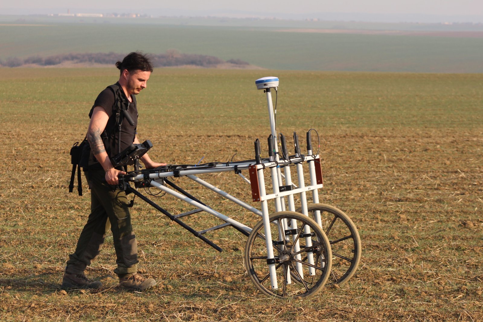
Our services

We specialize in high-resolution, non-invasive geomagnetic surveys for archaeology. Using a 5-channel SENSYS gradiometer, Sub Sol delivers insights into the past without disturbing the ground.

What Services We Offer

We provide a range of digital datasets including magnetometry

High-Resolution Magnetometric Surveys

With the help of non-invasive technology, we collect dense, precise magnetic data ideal for identifying archaeological features such as pits, walls, ovens, and ditches.

✔ 0.25 to 0.5 m sensor spacing
✔GPS-integrated survey
✔Rapid acquisition

Magnetogram Processing &Visualisation

High-resolution processing of gradiometer data for archaeological interpretation and documentation.

Archaeological Site Assessment

Our surveys support archaeological research, diagnostics, and heritage management. Detect structures, pathways, or settlement zones across a range of historical periods.

✔Identification of archaeological features (ditches, walls, pits, enclosures)
✔Anomaly classification based on shape, magnetic signature and context
✔Support for research publications or rescue archaeology documentation

GIS Mapping

We deliver georeferenced datasets compatible with QGIS, ArcGIS, AutoCAD and Global Mapper. Your data is ready for overlay with excavation maps, LiDAR, or aerial imagery.

✔Geo-referenced overlays for magnetograms
✔Integration with existing archaeological maps and site plans

Drone & LiDAR Overlay

Combine our magnetic data with high-resolution imagery or LIDAR terrain models for advanced landscape analysis.

✔High-resolution ortophoto and 3D modelling
✔Digital Elevation Models (DEM)

Reporting & Documentation

Final reports are tailored for academic or developer needs, including detailed interpretation, anomaly classification, and georeferenced maps.

✔ Project overview and methodology
✔ Anomaly mapping and classification
✔ Printable maps, charts and GIS files

Business Strategy

Neque aliquam vestibulum morbi blandit cursus risus at ultrices turpis nunc eget lorem.

Best Reasons To Choose Our Services

Nulla eleifend pulvinar purus, molestie euismod odio imperdiet amet erat nec nibh rhoncus varius in non lorem pretium viverra suspendisse.

Years of Experience
0 +
Happy Clients
0 k+
Satisfaction
0 %
Laurel Miller

Marketing Agency Director

5/5

Aenean sed nibh a magna posuere tempor. Nunc faucibus pellentesque nunc in aliquet donec congue nunc vel tempor congue.

Randy Wallace

Design Bureau Director

5/5

Donec congue, nunc vel tempor congue, enim sapien lobortis ipsumin volutpat sem ligula. Nunc purus est, consequat condimentum.

We Can Inspire And Transform Your Business

Maecenas interdum lorem eleifend orci aliquam mollis aliquam non rhoncus magna suspendisse aliquet tincidunt enim.

Project Management Tools

Lorem ipsum dolor sit amet, consectetur adipiscing elit sedudo.

Software Proposal

Lorem ipsum dolor sit amet, consectetur adipiscing elit sedudo.

Cloud Automation Architecture

Lorem ipsum dolor sit amet, consectetur adipiscing elit sedudo.

$999

Work Process

Data acquisition

High-precision field surveys using advanced magnetometry and drone technology. We use a multi-channel Sensys gradiometer equiped with RTK GPS to collect geo-referenced data with minimal ground disturbance.
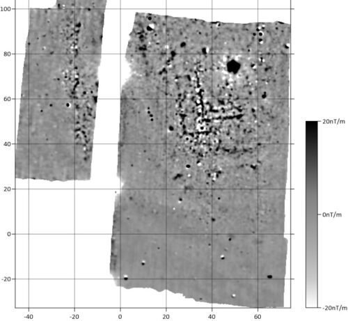
Data processing

Correction, filtering and georeferencing of magnetometric and Lidar data. We process raw sensor data into clean, interpretable magnetograms and terrain models.

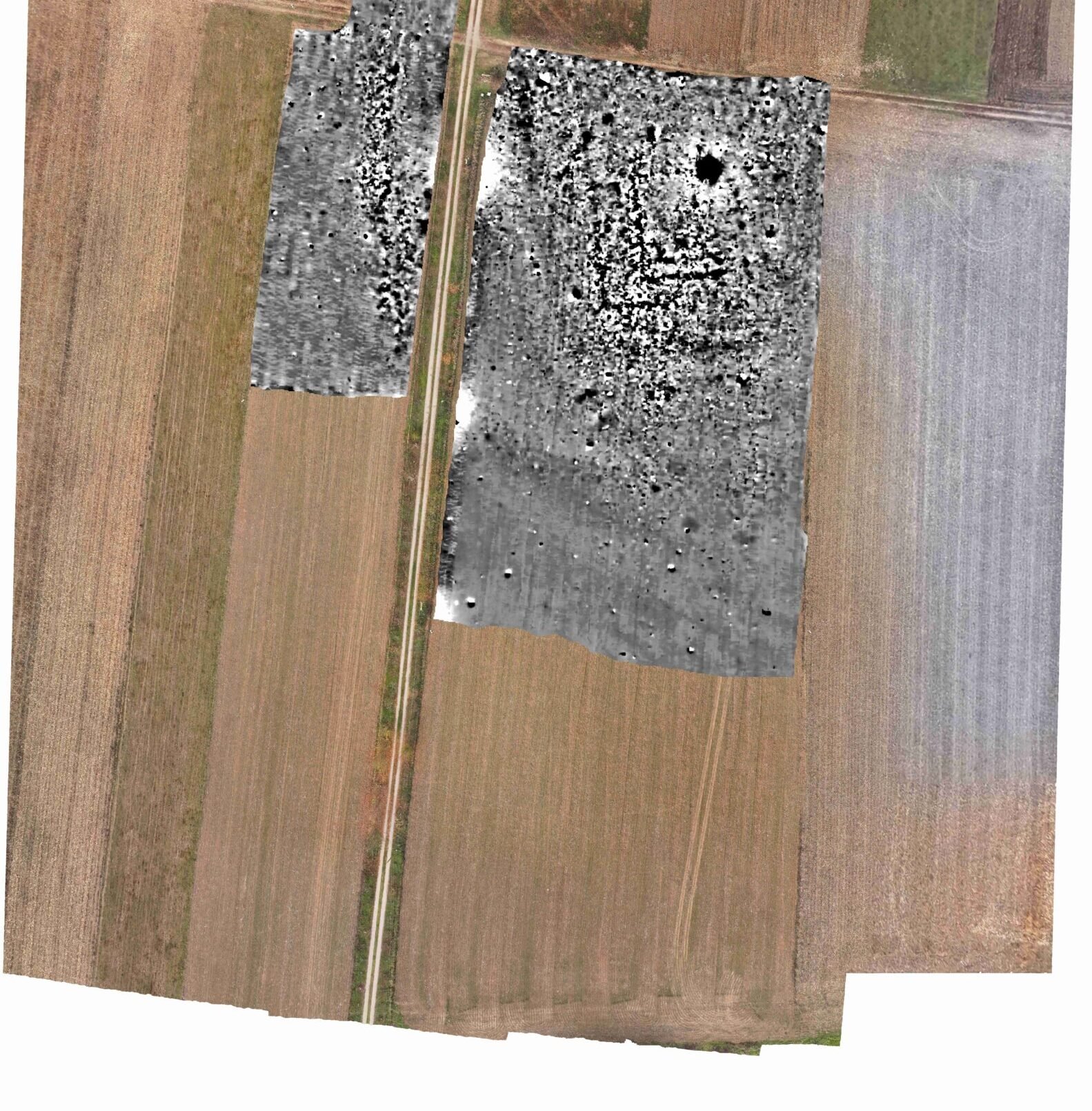
Interpretation & Aerial Overlay

Overlaying geomagnetic results with ortophotos and 3D terrain models for clear interpretation. We identify potential archaeological features, classify anomalies and deliver comprehenisve visual reports - ready for publications or submission to heritage agencies

Ready to survey your site?

Contact us to discuss your next excavation, research project, or heritage assessment.